 |
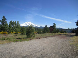
| Shooting range for firearms and archers, along Highway 99. |
There was a 2 hour leg of the journey I didn't document, but should have, between Burney Falls and the beginning of Highway 99 in Red Bluff, because some of that included dramatic vistas, such as seeing the snow-covered Trinity Alps in the distant West, some breath-taking views of Mount Lassen and other peaks in the NE part of California, as well as a variety of ecosystems. Highway 99 is another North-South Road, just a bit east of Interstate 5, and was the original road for the Central Valley.
Typical sights along 99.
Quite a few improvised signs advertising produce stands, and a mix of produce, including many well-established orchards along with new ones just planted.
Walnuts? I wonder how many of these folks will try to grow cannabis once it gets legalized? Then again, the prices will likely crater. Not like I care either way, just think prohibition never works.
Plenty of storage facilities.
Co-op in Chico, CA.
We saw so much rice being cultivated in the valley, and Chico's right in the middle of it.
Cal State Chico. Reputation as a real party school. Since Sierra Nevada is based there, no wonder. Nice looking town.
Rice fields. Note the water.
BBQ chicken stand. Nice smokey flavor, and he gave us a cup of salsa so picante I swear it grew some extra hairs on my chest, ears, eyebrows, and nether regions.
Kept thinking of that crop duster scene from North By Northwest.
Drawing close to "civilization." Nearly forgot to mention. The temperature from Redding all the way to a few miles east of Vallejo was around 98. Sure glad I don't live there.
And, finally, Woodland. From here, it was a short trip home.


